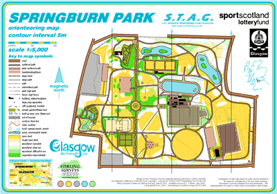
Springburn Park map
Springburn
Information
The area was mapped in the mid 1980s as a STAG Junior Project and was included in the first Glasgow Parks Summer Series in 1989. Another small park but with a variety of terrain it offers a good challenge.
There is a permanent orienteering course here.
SMARTPHONE Courses available Spring 2021.
The 10 controls will take about 30 minutes to walk round.
Springburn Park - Post 10 missing & 2 others are rotted/snapped. 4 sites to be relocated to permanent/painted markers. 90% in place. Start to be relocated to west most gate on Broomfield Road.
Contact established with 'Friends of Springburn Park' Group.
Park History:
Acquired in 1896.
Highest point is 351 feet above sea level.
Magnificient Rockery near Balgrayhill Rd. entrance.
Former Winter Gardens on site.
3 ponds which attract a variety of wildlife.
Peace Garden dedicated to the late Lord Provost, Bob Innes.
Springburn Elderly Mens Club building.
Bowling greens and play area.