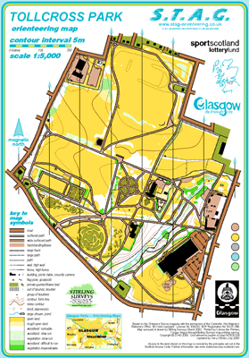
Tollcross Park map
Tollcross Park
Information
Tollcross Park was the first Glasgow Park mapped by STAG back in 1982 and played a vital part in the early development of the Club.
There is a permanent orienteering course here.
SMARTPHONE Courses available.
New Permanent Course installed, map updated Nov 2016 & relaunched in 2017.
Tollcross Park - 12 posts all in place. MapRun F courses available. 100%. Start from Play Area @ Sports Centre.
MapRun Courses available.
Previous attempts to establish a permanent course in 1986 and 1988 were unsuccessful but with the regeneration of the Park underway we are again hopefully that the 2016 Course shall be a success.
Bounded by Tollcross Rd., Wellshot Rd., Ardlui St.,Enterkin St., Anstruther St., Elvan St., Dalveen St., Shettleston Rd., St.Mark’s St., Edenwood St. & Muiryfauld Dv
Park History:
Acquired in 1896 covering 96 acres with extensive rose and floral displays.
Children’s Zoo and Play Area.
Swimming Pool and leisure complex.
Heritage Lottery Project helped restore the Winter Gardens re-opened November 2000.