Winter Score 1+ No.870.Strathclyde Country ParkSun 07 January, 2024

Local level event
Explanation of Event levels
Local events are usually low key and in the 'localised' area, ideal for newcomers to try the sport and Activities are non competitive events used for training and coaching, aimed at members of the club, but they can attract people from neighbouring clubs, and are often ideal for newcomers to try the sport. Regional events attract participants from around the local Region, National events are high quality competitions that will attract people from far away, Major events are Major Events such as a British Championships.
Results
Report
Many thanks to Mark, Christine, Thomas and Piers for covering Start/Registration/Download and to those who helped derig the Event - names to be added once I know them all.
We hope to see many, if not all of you next Sunday at Parkhill Wood, Lochwinnoch for WinterScore 2+.
Please note that Rudi, Helen and Ross opted to 'Twist' as is explained on your map.
Finally we send our best wishes to Robin and Sheila who became grandparents yesterday when Tessa & Murray had their first baby boy.
Regards
Terry
Location Info
Near: Motherwell Lat,Lng: 55.79783 ,-4.03524 OS Grid Ref: NS726579Postcode: ML4 2SE
Open an interactive map in:
GoogleMap -
Streetmap (OS 50k)
OpenStreetMap -
BingMap (OS 50k)
Directions / Parking
Plantation Car Park just east of M& Ds.
Public Transport Options
The nearest train station is at Airbles, Motherwell.
By Bus
Check out the Moovit website.
Hire bikes
No stations nearby.
Map / Terrain
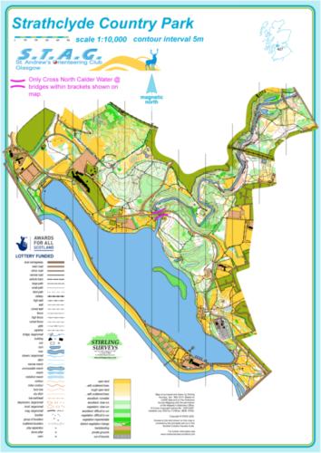
The map shall be printed at 1:7,500 with 5m contours.
Update as of 20th December 2023
Not surprisingly the area is very wet and this applies particularly to the open grass areas.
PERSONAL SAFETY
For your personal safety we advise that a studded pair of shoes are worn. Generally the running in and around Strathclyde Loch is straightforward.
Under NO CIRCUMSTANCES should any competitors contemplate crossing the North Calder Water anywhere except at the 2 bridges at the top(northern) and bottom (southern) end of the gorge. The Railway line is OUT OF BOUNDS as is the pipeline just to the north of the Railway Bridge.
North Calder Water Gorge West Side
On this side the path starts high up then drops down into the depth of the gorge to pass underneath the railway bridge. The path itself is undulating in nature with several sharp inclines to be negotiated. The 50m crags on the western side of the North Calder Water Gorge are impressive but should not be explored.
North Calder Water Gorge East Side
The path network is more extensive on this side and a recent Mountain Bike Course has been added to the map.
Registration and Start times
Pre-entry details at this link here
Limited entry on the day
Course Information
See information on the right of this page.
Update Saturday 6th January 9am - All extra maps have now been allocated.
Entry Details
See link above.
Dog restrictions
Well-behaved dogs on a lead.